Mapa interactivo de la ruta
Explora las paradas del viaje. Utiliza la rueda del ratón o dos dedos para ampliar y toca los marcadores.
La línea roja conecta los días del viaje. Si no se puede calcular la carretera o el sendero, el tramo se muestra de forma esquemática y no sirve para navegar. Routing powered by Mapbox ↗
Fotos de este viaje
El Pamir en 7 días con una distancia total de 1.650 km.
Dusambé – Khorog – Wakhan – Murghab – Karakul – Osh a través del Corredor de Wakhan
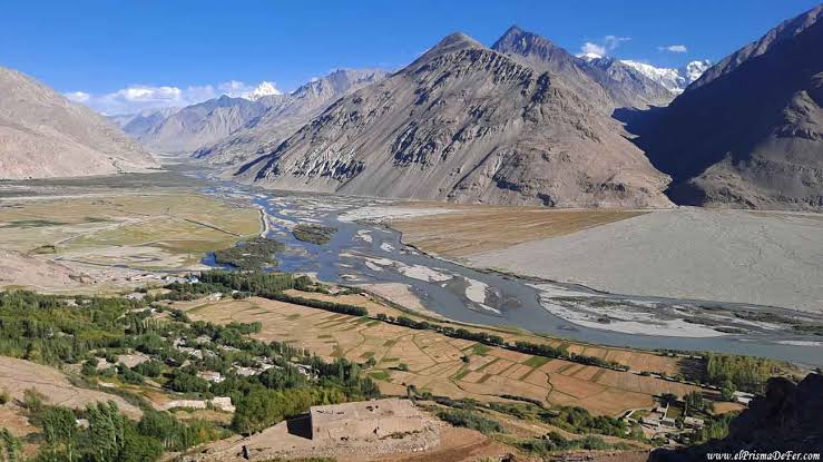
Lo que verás: el río Panj y sus gargantas a lo largo de la frontera afgana / el famoso valle de Wakhan / las antiguas fortalezas de Kah-Kaha y Yamchun (siglos III–I a. C.) / petroglifos / los fantásticos paisajes de Yashilkul / la meseta del Pamir
Lo que disfrutarás: lugares históricos / baños en aguas termales / impresionantes paisajes del Hindu Kush afgano / hospitalidad pamirí / posibilidad de observar patos y gansos de cabeza rayada (Anser indicus) en su hábitat natural.
Altitudes sobre el nivel del mar durante el día: inicio del día – 780 m en Dusambé, punto más alto – 2.126 m en el paso Shurobod, final del día – 1.295 m en Kalai-Khumb.
Tu itinerario
Kalai-Khumb – Khorog. 280km 8-10 hours of driving, the road is not so good.
Khorog City Tour: Botanical Garden, Historical Museum, City Park and Visit Tourism Information Center.
Overnight in a hotel or homestay in Khorog. 250 km.
Altitudes above sea level during the day: beginning of day – 1295m in Kalaikhumb, end of the day – 2100m in Khorog.
Khorog – Wakhan Corridor/Zong. 246km 10-12 hours of driving.
Yamchun fortresses, Bibi Fotima hot-spring, pre-Islamic shrines, Museum of Sufi Muboraki Wakhoni, astronomer and scholar of the 19 th century and if there enough time go for trekking to Langar petroglyphs. Overnight in a homestay in Langar or Zong village.
Altitudes above sea level during the day: beginning of day – 2100m in Khorog, highest point –Yamchun 3200m, end of day – Langar 3000m.
Zong (Wakhan)–Bulunkul/Yashikul lakes–Alichur-Murghab. 275km 10-12 hours of driving.
Altitudes above sea level during the day beginning of day – Langar 2900m, highest point – 4344 m on Khargush pass, end of day – 3630m
in Murgab.
Murghab–Modian-Modian.
from a different perspective. Picnic lunch on the shade of rare trees – on Murgab Riverbank. In the evening driving back to Murghab, in some parts go by walk, landscape so amazing. Also, it is possible to stay in tents close to the Murghab River. Otherwise overnight in a guesthouse in Murghab. 80km
Altitude above sea level during the day: beginning of the day – 3630m Murghab, in Madian village – 3500m.
Murghab – Karakul village. 210km 8-9 hours of driving.
Continue driving to Karakul village via the highest point of the Pamir Highway, Ak-Baital pass (4656 m). Short stop near the fist Tsarist Russian military base in the Pamirs. In the afternoon hiking along the Karakul lake. Overnight in a homestay or yurt in Karakul village.
Altitudes above sea level during the day: beginning of day – 3630m in Murgab highest point – 4656m on Ak-Baital pass, end of day – 3930m in Karakul.
Karakul – Sary Tash – Osh 294km 8-10 hours of driving.
Altitudes above sea level during the day: beginning of day – 3930m in Karakul highest point – 4282m on Qyzyl Art pass, end of the day – 950m in Osh.
Qué incluye
Transporte (vehículo 4×4), incluido el combustible
Comidas, incluyendo 1,5 litros de agua potable por persona y día
Alojamiento, incluyendo 1 noche en Dusambé y 1 noche en Osh
Entradas (aguas termales, museos, Jardín Botánico y Parque Nacional)
Permiso GBAO
Gastos administrativos, incluidos los impuestos
No incluido
Seguro
Servicio de guía
Suplemento por habitación individual
Todos los demás gastos personales
Billetes de avión
Bebidas alcohólicas
Gastos personales
Más aventuras
Nature
Jeep tour
Tour de trekking por la Patagonia asiática, montañas de Karavshin
Jeep tour
Tour privado por la carretera del Pamir (M-41)
Tu próxima aventura comienza aquí.
Cuéntanos cuándo y adónde quieres viajar. Te ayudaremos a planificar un viaje a tu medida.